| This page uses content from the English Wikipedia. The original article was at International Date Line. The list of authors can be seen in the page history. As with the Calendar Wikia, the text of Wikipedia is available under Creative Commons License. See Wikia:Licensing. |
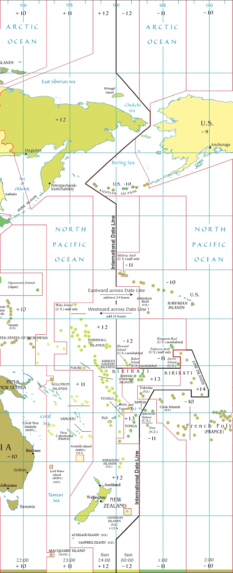
The International Date Line around 180°
The International Date Line (IDL), also known as just the Date Line, is an imaginary line on the surface of the Earth opposite the Prime Meridian which offsets the date as one travels east or west across it. Roughly along 180° longitude, with diversions to pass around some territories and island groups, it corresponds to the time zone boundary separating +12 and −12 hours GMT (UT1). Crossing the IDL travelling east results in a day or 24 hours being subtracted, and crossing west results in a day being added.
The first date-line problem occurred in association with the circumnavigation of the globe by Magellan's expedition (1519–1522). The surviving crew returned to a Spanish stopover sure of the day of the week, as attested by various carefully maintained sailing logs. Nevertheless, those on land insisted the day was different. Although now readily understandable, this phenomenon caused great excitement at the time, to the extent that a special delegation was sent to the Pope to explain this temporal oddity to him.
Geography[]
For a large part, the International Date Line follows the meridian of 180° longitude, roughly down the middle of the Pacific Ocean. However, because the date to the east of the line is one day earlier than that to the west of the line, the line deviates to pass around the far east of Russia and various island groups in the Pacific, no country wanting to have — at least during ordinary daytime hours — its citizens functioning on two different dates. Thus, the two largest deviations from this meridian both occur to keep the date line from crossing nations internally.
In the north, the date line swings to the east through Bering Strait and then west past the Aleutian Islands in order to keep Alaska (part of the United States) and Russia on opposite sides of the line and their territories due north and south of each other in concert with the date of the rest of each respective country. In the central Pacific, the date line was moved in 1995 to extend around, rather than through, the islands of the Republic of Kiribati. As a British colony, Kiribati was centered in the Gilbert Islands, just west of the International Dateline. Upon independence in 1979, the new republic acquired the Phoenix and Line Islands from the United States and the country found itself straddling the date line. Government offices on opposite sides of the line could only communicate on the four days of the week when both sides experienced weekdays simultaneously. A consequence of this time zone revision was that Kiribati, by virtue of its easternmost possession, uninhabited Caroline Atoll at 150°25′ west, started on its territory the year 2000 before any other country on earth, a feature which the Kiribati government capitalized upon as a potential tourist draw. However, even into the 21st century, many mapmakers (including Google Maps)[1] ignore this Kiribati dateline shift and continue to represent the International Date as a straight line in the Kiribati area.
In the South Pacific, the dateline swings east such that various islands administered by New Zealand (which lies west of 180°) are on the same date with New Zealand.
The International Date Line can cause confusion among airline travelers. The most troublesome situation usually occurs with short journeys from west to east. For example, to travel from Tonga to Samoa by air takes approximately two hours, but involves crossing the international date line, causing the passenger to arrive the day before they left. This often causes confusion in travel schedules.
If someone circumnavigates the globe in an airplane from east to west (the same direction as Magellan), he should subtract one hour for every 15° of longitude crossed, losing 24 hours for one circuit of the globe. But 24 hours are added when crossing the International Date Line (from east to west). The International Date Line must therefore be observed in conjunction with earth's time zones: the net adjustment to one's watch is zero. If one crosses the date line at precisely midnight, going westward, one skips an entire day; while going eastward, one repeats the entire day.
Cultural references[]
The effect of ignoring the date line is also seen in Jules Verne's novel Around the World in Eighty Days, in which the travelers, led by Phileas Fogg, return to London after a trip around the world, thinking that they have lost the bet that is the central premise of the story. Having circumnavigated in the direction opposite Magellan's, they believe the date there to be one day later than it truly is.
Lest anyone accuse Fogg of cheating by obtaining one extra day, this is not so. Assuming a constant eastward speed, each travel day was 18 minutes short of a full 24 hours, accumulating to one full day, which they failed to correct as we would by setting our calendar back a day in mid-Pacific.
Anyone traveling west and passing the line must add a day to what they would otherwise expect the date and time to be. Correspondingly, those going east must subtract a day. Magellan's crew and Verne's travelers neglected to make those respective adjustments.
De facto and de jure date lines[]
The IDL drawn on the map on this page and all other maps is now and always has been an artificial construct of cartographers — it is de facto (of fact). No international organization nor any treaty between nations has fixed the 'straight line' segments and their junctions. All nations unilaterally determine their standard time zones, which are applicable only on land and adjacent territorial waters. These national zones do not extend into international waters. Indeed, the 1884 International Meridian Conference explicitly refused to propose or agree to any time zones, despite 'common knowledge' that they did, stating that they were outside its purview. The conference resolved that the Universal Day (midnight-to-midnight Greenwich Mean Time), which it did agree to, "shall not interfere with the use of local or standard time where desirable."
However, the nautical date line which governs ships is determined by international agreement—it is de jure (of law). It is the result of the 1917 Anglo-French Conference on Time-keeping at Sea, which recommended that all ships, both military and civilian, adopt hourly standard time zones on the high seas. The United States, for example, adopted its recommendation for US military and merchant marine ships in 1920. This date line is implied but not explicitly drawn on time zone maps. It follows the 180° meridian except where it is interrupted by territorial waters adjacent to land, forming gaps—it is a pole-to-pole dashed line. Ships must adopt the standard time of a country if they are within its territorial waters, but must revert to international time zones (15° wide pole-to-pole gores) as soon as they leave its territorial waters. The 15° gore that is offset from GMT or UT1 (not UTC) by twelve hours is bisected by the nautical date line into two 7.5° gores that differ from GMT by ±12 hours.
Historical alterations[]
The Philippines, a Spanish colony until 1898, decidedly on the west side of the date line today, historically was on the east side, being in communication by ocean transport with Acapulco, Mexico. At 00:00 in London, Great Britain, 17:20 in Acapulco was about 08:04 in Manila. A 9 hour, 16 minute difference, Manila ran nearly a half-day behind Acapulco.
During the 1840s, trade interests turned to China, the Dutch Indies and adjacent areas, and the Philippines was changed to the west side of the date line. Monday, December 30, 1844 (ending up as a 365-day year) was followed by Wednesday, January 1, 1845.
Until 1867, Alaska began Russia's day, with the date line following the partially-defined border between Russian Alaska and British North America, including the colony of British Columbia. The day before the purchase by the United States took effect, it was Friday, October 6, 1867, in the Julian calendar (used by Russia at the time), which would have been October 18 in the Gregorian calendar. The time in New Archangel would have been 12:00 when it was 12:02, Thursday, October 17, at the future site of Whitehorse, Yukon and 12:49, October 17, at the future site of Vancouver, British Columbia.
With the transfer of governance, the date line was shifted (moving Alaska back a day), and the calendar was changed (moving Alaska ahead 12 days), and being effective at midnight, the calendar moved ahead one day as well, for a net change of 11 days. Friday, October 6 was followed by Friday, October 18, not October 7.
Western Samoa changed in 1892, eight years following the international conference that would result in de facto development of the Date Line. The king was persuaded by American traders to adopt the American date, being three hours behind California, to replace the former Asian date, being four hours ahead of Japan. The change was made at the end of the day, Monday, July 4, 1892, so that year, there were 367 days, including two occurrences of Monday, July 4.
Kiribati introduced a change of date for its eastern half, on January 1, 1995, from time zones −11 and −10 to +13 and +14. Before this, the country was divided by the date line. This meant that the date line in effect moved eastwards to go around this country.
Notes[]
External link[]
Template:Coor title d